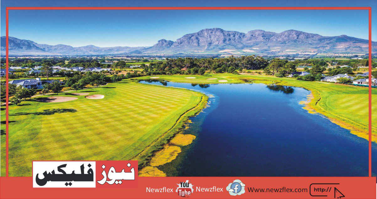
Pearl Valley
Rawalakot also called Pearl Valley is located in the heart of district Poonch of AJK. This beautiful valley is known for its breathtaking views and sceneries. It’s a saucer-shaped valley with an altitude of 1615m. It’s situated at a distance of 80km from Islamabad.
People in Rawalakot are very warm-hearted and welcoming. Hospitality is their passion. The city encompasses a mixture of luxury and necessary commodities of life available in numerous bazaars. Woolen clothes, shawls, and wooden carvings are very famous in these bazaars. Mushrooms, honey, walnuts, apples, cherry, medicinal herbs, and deodar are very famous there. Equipment for hiking like diggers, camping tents, stoves, and sleeping bags are available at very economical prices.
Weather
The weather in Rawalakot is sort of erratic. the typical temperature during the summer season varies from 25°C to 35°C. However, in winter there is heavy snowfall which starts in December and lasts till January. The winter season lasts from November to March. The valley also experiences the rainy season from April to June. The autumn season brings its own beauty the entire valley gets covered with hues of first gold, then russet then red. The weather throughout the year usually remains cold and chilly.
Attractions
The major attractions for tourists and travelers in Rawalokot include
- Mountain-based adventure tourism
- Hiking
- Mountaineering
- Trekking
- Summer camping
- Hiking
- Water-based adventure tourism
- Paragliding
Routes
From Islamabad/Rawalpindi it takes you about 2 and a half hours to succeed in this beautiful valley, via Azad Pattan and dhalkot. The Guoien Nalla road connecting Rwalapindi to Rawalakot through Azad Pattan had considerably reduced the traveling time. Throughout this road, there are amazing natural scenes to be seen.
Rawalakot has an airport but unfortunately, since 2001 it’s non-operational because PIA has stopped giving its services to this area.
Accommodation
Lodges, private and government-owned hotels, and guest houses are available in the area. Restaurants however don’t seem to be frequently found but traditional and continental foods are available in the hotels and guest houses. Gulf In Hotel is a major attraction for tourists.
Transport
Public transport is definitely available to Rawalakot.
KOYIAN
From Rawalakot after you move forward 17 kilometers ahead, there’s an area called Koyian surrounded by thick dense forests, which makes it fascinating and wonderful.
Koyian experiences erratic weather behavior. The summer season varies from 16°C to 24°C average temperature. The calm and serene environment and wonder hold the attention of the viewer.
Guest houses don’t seem to be easily available in the area however a Tourist Lodge has been constructed by the AJK tourism department. Koyian International Private Guest House Rawalakot is one of the famous guest houses in Koyian and a major attraction for tourists. Other than the government of Pakistan is additionally taking steps to improve the conditions of the area especially the drinking and sanitary facilities.
This place gives you easy access to Banjosa which is situated at a distance of only 5km from koyian.
BANJOSA LAKE
Moving forward approximately 20km from Rawalakot you reach this captivating beautiful place of Banjosa Lake. It’s situated at an altitude of 1981 meters.
The unique and interesting thing about this lake is that it’s a manmade land, the sole planned tourist resort in the place which implies that it’s a synthetic lake, not a natural lake. It’s very famous due to its beautiful and amazing views and fabulous greenery and lush green trees and mountains. The lake is the center of attraction because the water of the lake reflects the encompassing i.e. trees, flowers, and mountains which makes it unique and attracts tourists.
Weather
Banjosa Lake is a very cool and calm place. In summers the weather temperature is typically between 15°c to 25°c but the winters are very cold, and heavy snowfall is there which makes the lake frozen. The extreme winter months are January and February while the remainder of the year is moderate and pleasant. The valley enjoys monsoon also in the month of August and September when there’s heavy rain.
Attractions
One can enjoy the captivating great thing about the Lake, can enjoy boating, and swings for teenagers. The charge for sailing per person is Rs.200 depending upon the demand the speed can go high in summers. Staying in nearby constructed rest houses within the surroundings of the lake is a delightful experience.
Routes
These two routes to access this Lake from Rawalpindi first from kahuta road which takes approx. 3 hrs to succeed in Banjosa. The second route is through Mangla then kotli then khaigala and at last Banjosa Lake. Throughout the way, beautiful scenic beauty and natural views entertain you.
In close proximity, there are some beautiful places like Jandali situated at a distance of 4 km, Devi Gali at 12 km, and Toli Pir situated at 42 km from this lake. of these places reveal the gorgeous natural beauty expecting the visitors to come back and explore the natural beauty.
Accommodations/Facilities
Apart from PTDC motels and hotels private guest houses lodges and hotels also are available in the vicinity at reasonable prices ranging from Rs. 500. Like Tourist Lodge Banjosa, Abdali Guest House, Banjosa Road Chahar station to luxury hotels like Banjosa Night Bridge Guest House. you’ve got to form reservations of the hotel before visiting because the supply of rooms is restricted especially in the summer season.
Transport:
Public transport is definitely available from Rawalpindi to Banjosa. You’ll also hire a taxi which is able to cost the whole visit Rs.600 only.
JANDALI
Moving forward from Banjosa Lake a worth seeing place comes called Jandali located at a distance of 83 km from Islamabad. It’s a beautiful village located in the Rawalakot Tehsil of Poonch District. This beautiful attraction for tourists located in the hills above the Jhelum Valley is as eye-catching as other parts of Azad Kashmir.
This district was majorly plagued by the 2005 earthquake and also suffered from 2006 arrive Pakistan. However, this village is rich in inherent natural beauty which captivates the attention of the tourists.
The main language of the people living there’s Pahari.
Jandali is known for its chewing tobacco which is the major export there.
The place is definitely reachable through land routes and air routes moreover as there are almost 5 airports near the place Rawalakot Airport, Bhurban Heliport Airport, Muzaffarabad Airport, Abbottabad Airport, and Mansehra Airport.
Accommodation isn’t easily available however some private guest houses are available.
One of the famous guest houses in Jandali is “Jandali Hills Guest House” near Banjosa Lake and it’s a serious attraction for tourists and travelers visiting Jandali.
GHORI MAR
Moving approximately 30 km forward from Jandali the place of Ghori Mar comes which is nest to Phakhar. It’s a populated place situated in the Poonch district of AJK. Its original name (with diacritics) is Ghori Mār Dhok. It is located at a distance of 84km from Islamabad. It’s located at an elevation of 2357 meters.
You can easily reach this place via khaigala which is a fair-weather road resulting in Gori mar. From here the tourists and travelers can enjoy the breathtaking eye-catching scenic fantastic things about the sub valleys of Rawalakot and Bagh.
Accommodations are provided by AJK Tourism Department to the visitors of the Ghori Mar. Where one can find a comfortable environment to remain in and spend some time. Ghori mar building near Toli Pir is incredibly famous and provides comfortable accommodation.
Cities, towns, and places near Ghori Mar Dhok include Saujal, Dapli Pir, Sari Mang, and Soanj.
TOLI PIR
Toli Pir is a hilltop area situated in Tehsil Rawalakot in the Poonch District of Azad Kashmir. Its approximate height is about 8800 ft above sea level. It is about 30 km, or a 45-minute drive, from Rawalakot in Azad Kashmir.
It is the highest mountainous location in the northeastern area of Rawalakot; It is the point of origin of three different mountain ridges. The tourist rest house on the way to Toli Pir is also situated in a scenic location. There are some remains of an old Mazar on the highest hilltop.
A ridge is a geological feature consisting of a chain of mountains or hills that form a continuous elevated crest for some distance. Ridges are usually termed hills or mountains as well, depending on size.
Toli Pir is most accessible during the summer months; the weather is generally pleasant but becomes colder from October through March. The area’s natural beauty is at its peak from April to August.
The road access to Toli Pir is easy because of the mettle roads. Electricity facilities can also be availed in the area. There are beautiful rest houses located where the extremely scenic view can be enjoyed. The water in the area is available through the natural groundwater springs.
Toil Pir offers a peaceful and calm atmosphere. There is an immense number of lush green gardens and meadows with natural beauty. The area provides captivating views to tourists because of its unique charm.
Abbaspur, Bagh, and Poonch River are visible from the hilltop.
The beautiful snowcapped mountains of the Peer Panjal add to the magnificence of the area, it makes the place out of this world.
DEVI GALI
Devi Gali is a village situated in the heart of Poonch District of Azad Kashmir, Pakistan which is a great tourist attraction too. It is located 8 kilometers from Hajira, 12 kilometers from Banjosa, and 32 kilometers from Rawalakot an altitude of 5,480 feet. Devi Gali is connected with Hajira which is the tehsil headquarters and Tratkhal which is near Tasheel Sudhnoti
Devi Gali is known as Aamir Hussain Shaheed Gali abbreviated as Shaheed Gali which is a very serene place with a very delightful atmosphere. It has a lovely and attractive view because of its lush green grassy grounds surrounded by densely pine forests and mountains.
PANIOLA
Paniola is a town located on the road of Muzaffarabad near Rawalakot Azad Kashmir Pakistan. Paniola is situated 17 kilometers from Rawalakot towards Kohala and 52 kilometers from Kohala. The Tourism Department has constructed a rest house for tourists in the area because of its calm and charming characteristics. Transport can be easily availed for this area from Rawlakot. Other hotels and motels are here for the accommodation facility. Fast food and eatables are available here. Petrol pumps are available but CNG is not available here. ATM facility cannot be availed here so one needs to carry a sufficient amount of money while in the area. Transport facility is available throughout the area. Market and shopping centers provide all kinds of shopping materials from daily groceries to clothes and other small electronics. A mobile coverage facility will be soon available in the area. Initial health care facilities are also present.
HAJIRA
Hajira is a small town in the Poonch District of Azad Jammu Kashmir, Pakistan. It is the headquarters of Tehsil Hajira. Hajira is located at latitude 33° 46′ 18.12″ N, longitude 73° 73° 53′ 45.96″ E, and an altitude of 3168 feet. It is 27 kilometers which are almost 17miles from Rawalakot and 142 kilometers (88 miles) from Islamabad, Pakistan. The town is situated on the bank of the Rangar stream in a narrow small valley surrounded by hills. It is the nearest town to Indian-occupied Kashmir, specifically Poonch. The climate of Hajira Valley is moderate neither too cold nor too hot.
All the basic necessities of life can be availed in Hajira. Health and Education institutes exist in town. It is easily accessible from Rawalakot by road. Daily public transport is available from Rawalakot and Hajira and vice versa all day long. Hotels and guest houses are present for tourists’ easy stay. The town is covered by all GSM operators hence, mobile phones can be used. A market is also present with a variety of products.
The area has slight controversy since the people of Hajira have faced a lot of trouble in past because of its presence on the line of control (LOC) between India and Pakistan but recently cross border attacks from India have been stopped and Hajira has become a safer town because of the Indo–Pak agreement.
The 2005 Earthquake also demolished about a quarter of this town but after the reconstruction and rehabilitation process, the town has been rebuilt.
The education system in the area is vast. There is a Government Boys Degree College and a Government Girls Degree College in Hajira along with several other private colleges in the town. The literacy rate of this town is almost 60%. Almost Seventy percent of the population of Hajira earns a salary through foreign employment. Ten percent are doing government services and the rest own small businesses. At least one person almost from each family is doing his job in foreign countries, especially in the Middle East, Europe, UK.
Seven union councils (Sarari, Bango, Phagwati, Gammer, Akhorban, Dawarandi, and union council ) are attached to this city. The main villages attached to this valley are Narian, Kathiyara, Manjoura, PothiChapriyan, UodPhagwati, Dwarandi, Gangil tar, Davigali, etc.
TATTA PANI
From the end of the 17th century up to 1837 A.D, Poonch was ruled by different Muslim Rajas of Loran. It then fell into the hands of Raja FalzTalab Khan of Rajouri. In 1846, this area was handed over to Maharaja Ghulab Singh under the Treaty of Amritsar. Before this transfer, Poonch was considered a district of Lahore. Maharaja Ghulab Singh handed over Poonch and some other areas to his nephews, Jawahar Singh and Moti Singh, with the condition that they would not make any administrative change without the consent of the Maharaja of Kashmir.
Poonch was annexed and converted Into Jagir by Maharaja Han Singh in 1935-36 by the deposing Raja of Poonch the Dogras always found it difficult to establish their rule in Poonch. In 1947 when Pakistan came into being, the people of Poonch started an armed struggle against the Dogra and Indian forces and got the area liberated which now administratively stands divided into three districts namely Poonch Sudhnutti and Bagh, RawalakotKot, Muttay Khan, Chape-ni-Dahar(Gulshan-eShuhda),Banjosa, Koian, Ghori Maar &Tolipir.
Hot springs (TattaPani)
TattaPani is situated on the right bank of the river Poonch, at a distance of 29 kilometers from Hajeera, and is connected with two fair weather roads i.e. via Hajeera-Mandol and Balouch-Pakhonar road. It can also be reached from Kotli, the district headquarter district, by covering a distance of 29 meters.TattaPani is famous for the cure of skin &rheumatic ailments. AJK Tourism Department has constructed a tourist lodge and bathrooms for the convenience of the visitors here. Transport services for TattaPani are available in good numbers from all important points of the Poonch, Mirpur &Kotli districts of Azad Kashmir.
BAGH
Bagh is one of the cities and district headquarters of Bagh District which is one out of 8 districts of Azad Kashmir. This district was first a part of Poonch but then it was declared as a separate district in 1988. It has three subdivisions Bagh, Dheer Kot, and Haveli. To the north of the city there is Muzaffarabad and to the south Poonch is located. It is linked with Muzaffarabad, which is the capital of Azad Jammu and Kashmir, in two ways. One way is via Kohala which takes approximately 100 kilometers to reach Muzaffarabad. Kohala is the gateway to AJK. The other way is via Sudhan Gali which takes 80 kilometers. From Islamabad, it takes 205 Kilometers to reach Bagh.
Many years ago the landowner of this area cultivated a garden, which is called “Bagh” in the Urdu language. From this, it is given the name of Bagh. In that area now forest department of Azad Kashmir is located to encourage and preserve forestry. It is a mountainous area that slopes from northeast to southwest. The mountain range which passes from this region is the “Pir Panjal” range. This range is located in the inner Himalayas. It is the longest range in the lower Himalayas which goes across disputed Kashmir as well, even Muree and Galiyat Mountains are also situated in this range. The total area of the district Bagh is 1,368 square kilometers. The total population, according to a survey in 2009, is 503000 and the density is 424/kilometer square. The altitude of Bagh valley is 3405 feet.
Languages that are spoken in Bagh are Pahari, Potohari, and Majhi. However, a small fraction of people speaks Urdu and Punjabi as well. The people of Bagh are very brave, courageous, and skilled. Two flour mills are operating in Bagh one at Kohala and the other one at Arja.
Bagh has a little part of tourism for everyone, every individual, and every market. Those who want to visit culture can look at its rich culture, those who are interested in history can look at the fascinating history of Bagh and of course, beautiful tourist attractions are also there. Following are a few of the beautiful places in Bagh which are attracting a lot of tourists from abroad and Pakistani people as well.
DHEER KOT
Dheer Kot is a town and one of the subdivisions of the Bagh District. It is situated 25 kilometers from Kohala. It is a very fascinating and charming place for people, who live in the hustle and bustle of cities, due to its lovely climate and healthy environment which is very close to nature. A very peaceful place with a beautiful landscape. It is famous for its easy access, apart from that, thick calm forests and beautiful scenery make it an attractive place to visit.
LASDANA
From Bagh city, it takes 15 kilometers to reach Lasdana. There is a metal unpaved road that leads to Lasdana however, that way is not so rough, one can reach it in 30 to 45 minutes. There is a tourism rest house in Lasdana constructed by the tourism department. Keeping stay at this rest house, tourists can visit several beautiful places adjacent to Lasdana. These places include Mahmood Gali, Kahuta, and kailer. All these places are just 15 to 20 kilometers away from Lasdana.
Panjal Mastan National Park
It is a tourist resort in Bagh valley. A very pleasant, fascinating, charming place and one of the beautiful plains of this valley. The elevation of this area is 2800 meters above sea level and it covers an area of 300 square kilometers. It is famous for its popular flora and fauna of the Pir Panjal range. In the spring season, this park is covered by wildflowers of this region and gives a view of heaven.
HAJI PIR PASS
Haji Pir pass is situated 32 kilometers from Bagh and has significant strategic importance as it connects Azad Kashmir to Indian Disputed Kashmir via Uri. This pass is situated on Uri-Poonch road and it is famous for its history. People cannot forget the Battle of Haji Pir Pass in 1965 which was the result of Pakistan’s infiltration in Kashmir against India under the name of operation Gibraltar. It is a very tough place for battle due to strenuous climbing still problems are created at this Pass even now when there is a stretch in India-Pakistan relations. It was occupied by Indian forces in the war of 1965 however; it was given back to Pakistan as a result of the treaty of Tashkand held between India and Pakistan to bring this war to an end. A major portion of Uri- Poonch road is under the control of Pakistani forces and a few heights are also captured by our forces from which they can have a constant eye on the activities of Indian forces in Indian Disputed Poonch.
Haji Pir Pass is named “Haji Pir” because right over the pass is the shrine of a Muslim Saint Hazrat haji Pir. His ‘Urs’ is held at this place every year and a lot of people come to the Urs to pray for the fulfillment of their wishes. Apart from the scenic beauty, it attracts tourists due to its history and strategic importance.
SUDHAN GALI
Sudhan Gali is a part of the Bagh district and is situated on the main road that connects Bagh to Muzaffarabad. There is a two-hour drive from Muzaffarabad to Sudhan Gali. It is located at a height of 2134 meters above sea level. There are two guest houses constructed in this region for tourists. Summer is the best season to visit this place however, despite land sliding, it is accessible throughout the year. Sudhan Gali has forests that have rare pine trees and some of them are even a hundred years old. It serves as a base camp for trekking near mountains including Pir Kanthi peak and Ganga Choti.
SER GROUND
Ser ground is a cricket ground located near Ganga peak and is situated between two mountains. It is a beautiful ground where tourists come and enjoy cricket matches every year.
There are sixteen teams from Muzaffarabad and Bagh, which participate in cricket tournaments. This is a huge tourist attraction in this region, especially in the seasons of summer and spring.
GANGA CHOTI
The most famous and beautiful place in the region of Bagh is Ganga Choti. Due to its fascinating and captive beauty, it is known as the “Crown of Bagh”. It is also situated in the Pir Panjal range. A lot of foreigners and local tourists come to trek this mountain. Sudhan Gali is the base camp for trekking Ganga Choti. It is a lifetime adventurous experience to trek this choti. It is three to four hours of tough trekking because a trekker gets height at every step. Trek from base to the choti is bordered by thick forests of pine trees and at night stray dogs and other animals also come around, therefore, one must be very careful and go with a guide. The most suitable season for trekking Ganga Choti is the summer and spring seasons from April to September. One can easily stay at one of the tourist’s guest houses in Sudhan Gali and take out one day for trekking this mountain.
Ganga Lake
There is a lake near Ganga Choti which is known as Ganga Lake. This lake is located at a height of 9655ft. A very calm and peaceful place that adds to the beauty of this area. However, it is not easily accessible as only a jeep track leads to this lake. Those who want to visit can hire a jeep from Bagh and reach the lake via jeep track.
NEELA BUTT
Neela Butt is a part of the Bagh district and is located 36 kilometers from Bagh city. It is situated at a height of 6600 ft. Apart from the stunning and beautiful scenery, it is famous for its historic background. Kashmir movement was initiated at this place and there is a monument constructed in memory of this movement known as the “Neela Butt Monument”. Mujahideen e Kashmir got together and raised a voice under the leadership of Sardar Abdul Qayyum Khan whose role is very significant in the Kashmir liberation movement. They raised voices against Maharaja Hari Singh in 1947. He and his ancestors sold Kashmir, without the consent of Kashmiris, against their own interests and very little money which was not equal to even a very small part of the value of this region. Hence, Sardar Abdul Qayyum Khan with some of his companions started this movement and it was initiated at this place known as Neela Butt. This place has a huge attraction for tourists who are interested in history. This area is easily accessible and only 6 kilometers away from Dheer Kot.
Tourists can reach all the above-mentioned areas easily. If they have their own car or van, it is good enough. However, local transport is also available from the capitals of both states, that is, Muzaffarabad and Islamabad. Tourists’ guest houses are also there to provide them with the facilities and make their journey a memorable one.
After exploring all the stunning places mentioned above, it can be said that these places are worth visiting. Most people plan their holidays and go to Switzerland, Italy, Venus or France where they are treated as a second-grade citizens and pay a lot of money to say “wow” on someone other’s land. But after exploring this region they would certainly realize what they have been missing in Pakistan. The best thing for Pakistanis visiting their own area is that here they are free to go anywhere and visit places that are equal in beauty and peace to any other place outside Pakistan. Hence, we Pakistanis should take pride in our own country and should explore the natural beauty God has blessed our country with.
پرل ویلی
راولاکوٹ کو پرل ویلی کے نام سے بھی جانا جاتا ہے ، اے جے کے کے ضلع پونچ کے مرکز میں واقع ہے۔ یہ خوبصورت وادی اپنے دم توڑنے والے نظاروں اور مناظر کے لئے مشہور ہے۔ یہ ایک طشتری کی شکل والی وادی ہے جس کی اونچائی 1615 میٹر ہے۔ یہ اسلام آباد سے 80 کلومیٹر کے فاصلے پر واقع ہے۔
راولاکوٹ میں لوگ بہت گرم دل ہیں اور اچھا استقبال کرتے ہیں۔ مہمان نوازی ان کا جذبہ ہے۔ اس شہر میں عیش و آرام کی اور زندگی کی ضروری اجناس کا مرکب مختلف بازاروں میں دستیاب ہے۔ اونی کپڑے ، شال ، لکڑی کے نقش و نگار ان بازوں میں بہت مشہور ہیں۔ مشروم ، شہد ، اخروٹ ، سیب ، چیری ، دواؤں کی جڑی بوٹیاں ، دیوڈر وہاں بہت مشہور ہیں۔ پیدل سفر کے لیے سامان جیسے کھودنے والے ، کیمپنگ کے خیمے ، چولہے اور سونے والے تھیلے بہت معاشی قیمت پر دستیاب ہیں۔
موسم
موسم گرما کے موسم کے دوران اوسط درجہ حرارت 25 ° سی سے 35 °سی تک مختلف ہوتا ہے۔ تاہم سردیوں میں شدید برف باری ہوتی ہے جو دسمبر اور آخری جنوری سے شروع ہوتی ہے۔ سردیوں کا موسم نومبر سے مارچ تک جاری رہتا ہے۔ وادی میں اپریل سے جون تک بارش کے موسم کا بھی تجربہ ہوتا ہے۔ موسم خزاں کا موسم اپنی خوبصورتی لاتا ہے جو پوری وادی پہلے سونے ، پھر رسٹ اور پھر سرخ رنگ کے رنگوں سے ڈھک جاتی ہے۔ سال بھر کا مجموعی موسم عام طور پر سرد رہتا ہے۔
پرکشش مقامات
راولوکوٹ میں سیاحوں اور مسافروں کے لئے بڑے پرکشش مقامات میں شامل ہیں
نمبر1:ماؤنٹین پر مبنی ایڈونچر ٹورزم
نمبر2:راک پر چڑھنا
نمبر3:کوہ پیما
نمبر4:ٹریکنگ
نمبر5:موسم گرما میں کیمپنگ
نمبر6:پیدل سفر
نمبر7:پانی پر مبنی ایڈونچر ٹورزم
نمبر8:پیرا گلائڈنگ
راستے
اسلام آباد/راولپنڈی سے آپ کو اس خوبصورت وادی تک پہنچنے میں تقریبا ڈھائی گھنٹے لگتے ہیں ، ازد پٹن اور ڈھالکوٹ کے توسط سے۔ گوئین نالہ روڈ جو روالپنڈی کو آزاد پٹان کے توسط سے راولاکوٹ سے جوڑتی ہے اس نے سفر کے وقت میں کافی حد تک کمی کردی تھی۔ اس پورے سڑک پر حیرت انگیز قدرتی مناظر دیکھنے کو ملتے ہیں۔
راولاکوٹ کے پاس ایک ہوائی اڈہ ہے لیکن بدقسمتی سے 2001 کے بعد سے یہ غیر آپریشنل ہے کیونکہ پی آئی اے نے اس علاقے میں اپنی خدمات دینا بند کردی ہے۔
رہائش
اس علاقے میں لاجز ، نجی اور حکومتوں کی ملکیت ہوٹل اور گیسٹ ہاؤس دستیاب ہیں۔ تاہم ریستوراں کثرت سے نہیں پائے جاتے ہیں لیکن روایتی اور براعظم کھانے کی اشیاء ہوٹلوں اور مہمانوں کے گھروں میں دستیاب ہیں۔ خلیج میں ہوٹل سیاحوں کے لئے سب سے بڑی توجہ ہے۔
ٹرانسپورٹ
پبلک ٹرانسپورٹ آسانی سے راولاکوٹ پر دستیاب ہے۔
کوئین
راولاکوٹ سے جب آپ 17 کلومیٹر کے بعد آگے بڑھتے ہیں تو ، وہاں ایک ایسی جگہ ہے جس کو کوئین نامی موٹی گھنے جنگلات سے گھرا ہوا ہے ، جو اسے دلچسپ اور خوبصورت بنا دیتا ہے۔
کوئین کو موسم کے غلط سلوک کا سامنا کرنا پڑتا ہے۔ موسم گرما کا موسم 16 ° سی سے 24 ° سی اوسط درجہ حرارت تک مختلف ہوتا ہے۔ پرسکون اور پر سکون ماحول اور خوبصورتی دیکھنے والے کی نگاہ کو برقرار رکھتی ہے۔
اس علاقے میں گیسٹ ہاؤسز آسانی سے دستیاب نہیں ہیں تاہم محکمہ اے جے کے سیاحتی لاج کو محکمہ اے جے کے نے تعمیر کیا ہے۔ کوئین انٹرنیشنل پرائیویٹ گیسٹ ہاؤس راولاکوٹ کوئین کے مشہور مہمانوں میں سے ایک ہے اور سیاحوں کے لئے ایک بڑی کشش ہے۔ اس کے علاوہ حکومت پاکستان بھی اس علاقے کے حالات کو بہتر بنانے کے لئے اقدامات کر رہی ہے
یہ جگہ آپ کو بنجوسا تک آسان رسائی فراہم کرتی ہے جو کوئین سے صرف 5 کلومیٹر کے فاصلے پر واقع ہے۔
بنجوسا جھیل
راولاکوٹ سے تقریبا 20 کلومیٹر دور آگے بڑھتے ہوئے آپ بنجوسا جھیل کے اس دلکش خوبصورت مقام تک پہنچتے ہیں۔ یہ 1981 میٹر کی اونچائی پر واقع ہے۔
اس جھیل کے بارے میں انوکھی اور دلچسپ بات یہ ہے کہ یہ ایک انسان سے تیار کردہ سرزمین ہے ، اس جگہ کا واحد منصوبہ بند سیاحتی حربہ ہے جس کا مطلب ہے کہ یہ مصنوعی جھیل ہے جو قدرتی جھیل نہیں ہے۔ یہ اس کے خوبصورت اور حیرت انگیز نظاروں اور شاندار ہریالی اور سرسبز سبز درختوں اور پہاڑوں کی وجہ سے بہت مشہور ہے۔ جھیل کشش کا مرکز ہے کیونکہ جھیل کا پانی آس پاس کے درختوں ، پھولوں اور پہاڑوں کی عکاسی کرتا ہے جو اسے منفرد بناتا ہے اور سیاحوں کو راغب کرتا ہے۔
موسم
بنجوسا جھیل ایک بہت ہی عمدہ اور پرسکون جگہ ہے۔ موسم گرما میں موسم کا درجہ حرارت عام طور پر 15 ° سی سے 25 ° سی کے درمیان ہوتا ہے لیکن سردیوں میں بہت سردی ہوتی ہے ، شدید برف باری ہوتی ہے جس کی وجہ سے جھیل منجمد ہوجاتی ہے۔ انتہائی سردیوں کے مہینے جنوری اور فروری ہیں جبکہ باقی سال اعتدال پسند اور خوشگوار ہے۔ وادی اگست اور ستمبر کے مہینے میں بھی مون سون سے لطف اندوز ہوتی ہے جہاں شدید بارش ہوتی ہے۔
جانی
بنجوسا جھیل سے آگے بڑھتے ہوئے ایک قابل جگہ جگہ کو اسلام آباد سے 83 کلومیٹر کے فاصلے پر واقع جندالی کہا جاتا ہے۔ یہ خوبصورت گاؤں ہے جو ضلع پونچ کے راولاکوٹ تحصیل میں واقع ہے۔
یہ ضلع 2005 کے زلزلے سے بڑے پیمانے پر متاثر ہوا تھا اور 2006 میں پاکستان میں سیلاب سے بھی دوچار تھا۔ تاہم یہ گاؤں موروثی قدرتی خوبصورتی سے مالا مال ہے جو سیاحوں کی آنکھ کو موہک کرتا ہے۔ وہاں رہنے والے لوگوں کی اصل زبان پہاری ہے۔
جنڈلی اپنے چیونگ تمباکو کے لئے مشہور ہے جو وہاں کی سب سے بڑی برآمد ہے۔
زمین کے راستوں اور ہوائی راستے کے ذریعے یہ جگہ آسانی سے قابل رسائ ہے اور ساتھ ہی ساتھ ہی جگہ کے قریب 5 ہوائی اڈے موجود ہیں جو جگہ راولاکوٹ ہوائی اڈے ، بھوربن ہیلی پورٹ ہوائی اڈے ، مظفر آباد ہوائی اڈے ، ایبٹ آباد ہوائی اڈے اور مانسہرا ہوائی اڈے کے قریب موجود ہیں۔رہائش آسانی سے دستیاب نہیں ہے تاہم کچھ نجی مہمان ہاؤس دستیاب ہیں۔
جانی کے مشہور مہمانوں میں سے ایک بنجوسا جھیل کے قریب “جندالی ہلز گیسٹ ہاؤس” ہے اور یہ جنڈلی آنے والے سیاحوں اور مسافروں کے لئے ایک بہت بڑی توجہ ہے۔
گھوری مار
جندالی سے تقریبا 30 30 کلومیٹر آگے بڑھتے ہوئے گھوری مار کی جگہ آتی ہے جو فاکھر سے گھوںسلا ہے۔ یہ ایک آبادی والی جگہ ہے جو اے جے کے کے ضلع پونچ میں واقع ہے۔ اس کا اصل نام (ڈایگریٹکس کے ساتھ) گھوری مور ڈھوک ہے۔ آئی ایس اسلام آباد سے 84 کلومیٹر کے فاصلے پر واقع ہے۔ یہ 2357 میٹر کی بلندی پر واقع ہے۔
آپ آسانی سے کھالہ کے راستے اس جگہ تک پہنچ سکتے ہیں جو ایک منصفانہ ہے کہ آیا سڑک گوری مار کی طرف جاتا ہے۔ یہاں سے سیاح اور مسافر راولاکوٹ اور باغ کی ذیلی وادیوں کی خوبصورت خوبصورتی کو پکڑنے والی آنکھوں سے لطف اندوز ہوسکتے ہیں۔
محکمہ اے جے کے سیاحت کے ذریعہ رہائش گوری مارچ کے زائرین کو فراہم کی جاتی ہے جہاں کسی کو رہنے اور کچھ وقت گزارنے کے لئے آرام دہ ماحول مل سکتا ہے۔ ٹولی پیر کے قریب گھوری مار ریسٹ ہاؤس بہت مشہور ہے اور آرام دہ رہائش فراہم کرتا ہے۔ گھوری مار دھوک کے قریب شہروں ، قصبے اور مقامات میں سوجال ، ڈالی پیر ، ساڑی منگ اور سوانج شامل ہیں۔
ٹولی پیر
ٹولی پیر ایک پہاڑی کی چوٹی کا علاقہ ہے جو آزاد کشمیر کے ضلع پونچ میں تحصیل راولاکوٹ میں واقع ہے۔ اس کی تقریبا اونچائی سطح سمندر سے 8800 فٹ بلندی پر ہے۔ یہ تقریبا 30 کلومیٹر ، یا 45 منٹ کی ڈرائیو ، آزاد کشمیر میں راولاکوٹ سے ہے۔
یہ راولاکوٹ کے شمال مشرقی علاقے میں سب سے اونچا پہاڑی مقام ہے۔ یہ تین مختلف پہاڑ کی دھاروں کی اصل نقطہ ہے۔ ٹولی پیر کے راستے میں سیاحوں کا ریسٹ ہاؤس بھی ایک قدرتی مقام پر واقع ہے۔ اونچی پہاڑی چوٹی پر ایک پرانے مزار کی کچھ باقیات ہیں۔
ایک رج ایک ارضیاتی خصوصیت ہے جس میں پہاڑوں یا پہاڑیوں کی زنجیر پر مشتمل ہے جو کچھ فاصلے کے لئے ایک مسلسل ایلیویٹڈ کرسٹ تشکیل دیتا ہے۔ سائز پر منحصر ہے ، عام طور پر پہاڑیوں یا پہاڑوں کو بھی کہا جاتا ہے۔ گرمیوں کے مہینوں میں ٹولی پیر سب سے زیادہ قابل رسائی ہے۔ موسم عام طور پر خوشگوار ہوتا ہے لیکن اکتوبر سے مارچ تک ٹھنڈا ہوجاتا ہے۔ اس علاقے کی قدرتی خوبصورتی اپریل سے اگست تک عروج پر ہے۔
ٹولی پیر تک سڑک تک رسائی آسان سڑکوں کی وجہ سے آسان ہے۔ علاقے میں بجلی کی سہولت بھی حاصل کی جاسکتی ہے۔ یہاں خوبصورت آرام والے مکانات موجود ہیں جہاں انتہائی قدرتی نظارے سے لطف اندوز ہوسکتے ہیں۔ اس علاقے میں پانی قدرتی زمینی پانی کے چشموں کے ذریعے دستیاب ہے۔ محنت پیر پرامن اور کلیم ماحول پیش کرتا ہے۔ قدرتی خوبصورتی کے ساتھ سرسبز سبز باغات اور گھاس کا میدان ہے۔ یہ علاقہ سیاحوں کو اس کے انوکھے دلکشی کی وجہ سے سحر انگیز نظریہ فراہم کرتا ہے۔
ابباسپور ، باغ اور دریائے پونچ پہاڑی کی چوٹی سے دکھائی دے رہے ہیں۔
ہم مرتبہ پنجل کے خوبصورت برف سے چلنے والے پہاڑوں نے اس علاقے کی عظمت کو بڑھا دیا
دیوی گالی
دیوی گالی ایک گاؤں ہے جو پاکستان کے شہر پونچ ضلع آزاد کے مرکز میں واقع ہے جو سیاحوں کی ایک بہت بڑی توجہ بھی ہے۔ یہ حاجیرا سے 8 کلومیٹر ، بنجوسا سے 12 کلومیٹر دور ، اور راولاکوٹ سے 32 کلومیٹر دور 5،480 فٹ کی اونچائی پر واقع ہے۔ دیوی گالی حاجیرہ کے ساتھ جڑی ہوئی ہے جو تہسیل ہیڈ کوارٹر اور ٹراٹخال ہے جو تیشیل سدھنوٹی کے قریب ہے
دیوی گیلی کو عامر حسین شہید گالی کے نام سے جانا جاتا ہے جس کا خلاصہ شہید گالی کے نام سے کیا گیا ہے جو ایک بہت ہی خوشگوار ماحول ہے جس میں ایک بہت ہی خوشگوار ماحول ہے۔ گھنے دیودار جنگل اور پہاڑوں سے گھرا ہوا سبز گھاس گراؤنڈ کی وجہ سے اس کا ایک خوبصورت اور پرکشش نظارہ ہے۔
پینیولا
پینیولا ایک قصبہ ہے جو راولاکوٹ آزاد کشمیر پاکستان کے قریب مظفر آباد کی سڑک پر واقع ہے۔ پانیولا راولاکوٹ سے 17 کلومیٹر دور کوہالا کی طرف اور کوہالا سے 52 کلومیٹر دور واقع ہے۔ محکمہ سیاحت نے اپنی پرسکون اور دلکش خصوصیات کی وجہ سے علاقے میں سیاحوں کے لئے ایک ریسٹ ہاؤس تعمیر کیا ہے۔ اس علاقے کے لئے رالکوٹ سے آسانی سے نقل و حمل کا فائدہ اٹھایا جاسکتا ہے۔ رہائش کی سہولت کے لئے دوسرے ہوٹل اور موٹل یہاں موجود ہیں۔ فاسٹ فوڈ اور کھانے کے قابل یہاں دستیاب ہیں۔ پٹرول پمپ دستیاب ہیں لیکن یہاں سی این جی دستیاب نہیں ہیں۔ یہاں اے ٹی ایم کی سہولت حاصل نہیں کی جاسکتی ہے لہذا کسی کو علاقے میں رہتے ہوئے کافی رقم لے جانے کی ضرورت ہے۔ پورے علاقے میں نقل و حمل کی سہولت دستیاب ہے۔ مارکیٹ اور شاپنگ سینٹرز روزانہ گروسری سے لے کر کپڑوں اور دیگر چھوٹے الیکٹرانکس تک ہر طرح کے خریداری کا سامان مہیا کرتے ہیں۔ موبائل کوریج کی سہولت جلد ہی علاقے میں دستیاب ہوگی۔ صحت کی دیکھ بھال کی ابتدائی سہولیات بھی موجود ہیں۔
حاجیرا
حاجیرا پاکستان کے آزاد جموں کشمیر کے ضلع پونچ کا ایک چھوٹا سا قصبہ ہے۔ یہ تحصیل حاجیرا کا ہیڈ کوارٹر ہے۔ حاجیرا عرض البلد 33 ° 46 ′ 18.12 ″ این ، طول البلد 73 ° 73 ° 53 ′ 45.96 ″ ای اور 3168 فٹ کی اونچائی پر واقع ہے۔ یہ 27 کلومیٹر ہے جو راولاکوٹ سے تقریبا 17 میل اور اسلام آباد ، پاکستان سے 142 کلومیٹر (88 میل) دور ہے۔ یہ قصبہ پہاڑیوں سے گھرا ہوا ایک تنگ چھوٹی وادی میں رنگار ندی کے کنارے واقع ہے۔ یہ ہندوستانی مقبوضہ کشمیر کا قریب ترین شہر ہے ، خاص طور پر پونچ۔ وادی حاجیرہ کی آب و ہوا اعتدال پسند ہے نہ تو زیادہ سرد ہے اور نہ ہی زیادہ گرم۔
حاجیرا میں زندگی کی تمام بنیادی ضروریات کا فائدہ اٹھایا جاسکتا ہے۔ شہر میں صحت اور تعلیم کے ادارے موجود ہیں۔ یہ سڑک کے ذریعے راولاکوٹ سے آسانی سے قابل رسائی ہے۔ روزانہ پبلک ٹرانسپورٹ راولاکوٹ اور حاجیرا اور اس کے برعکس سارا دن دستیاب ہے۔ ہوٹلوں اور مہمان ہاؤسز سیاحوں کے آسان قیام کے لئے موجود ہیں۔ اس شہر کو جی ایس ایم کے تمام آپریٹرز نے احاطہ کیا ہے لہذا ، موبائل فون استعمال کیے جاسکتے ہیں۔ ایک مارکیٹ مختلف قسم کے مصنوعات کے ساتھ بھی موجود ہے۔
اس علاقے میں تھوڑا سا تنازعہ کم ہے کیونکہ حاجیرا کے لوگوں کو ماضی میں بہت پریشانی کا سامنا کرنا پڑا ہے کیونکہ ہندوستان اور پاکستان کے مابین لائن آف کنٹرول (ایل او سی) پر اس کی موجودگی کی وجہ سے لیکن حال ہی میں ہندوستان سے سرحد پار سے ہونے والے حملوں کو روک دیا گیا ہے اور حاجیرا ایک محفوظ شہر بن گیا ہے۔
2005 کے زلزلے نے بھی اس قصبے کا ایک چوتھائی حصہ منہدم کردیا لیکن تعمیر نو اور بحالی کے عمل کے بعد ، اس شہر کو دوبارہ تعمیر کیا گیا ہے۔
اس علاقے میں نظام تعلیم بہت وسیع ہے۔ حجیرا میں گورنمنٹ بوائز ڈگری کالج اور گورنمنٹ گرلز ڈگری کالج ہے اور اس شہر میں کئی دوسرے نجی کالجوں کے ساتھ۔ اس قصبے کی خواندگی کی شرح تقریبا 60 60 ٪ ہے۔ حاجیرا کی آبادی کا تقریبا ستر فیصد غیر ملکی ملازمت کے ذریعہ تنخواہ حاصل کرتا ہے۔ دس فیصد سرکاری خدمات انجام دے رہے ہیں اور چھوٹے چھوٹے کاروباروں کو آرام کر رہے ہیں۔ ہر خاندان سے کم از کم ایک شخص خاص طور پر مشرق وسطی ، یورپ ، برطانیہ میں بیرونی ممالک میں اپنا کام کر رہا ہے۔
اس شہر کے ساتھ سات یونین کونسلیں (سراری ، بنگو ، فگوتی ، گامر ، اخوربن ، دوارانڈی اور یونین کونسل نر) منسلک ہیں۔ اہم دیہات اس وادی کے ساتھ منسلک ہیں: نیرین ، کتھیارہ ، منجورا ، پوتھیچپریان ، یوڈفگوتی ، دوارندی ، گینگیل ٹار ، ڈیوگلی وغیرہ۔
ٹٹا پانی
17 ویں صدی کے آخر سے لے کر 1837 تک اے ڈی پونچ پر لوران کے مختلف مسلم راجوں نے حکمرانی کی۔ اس کے بعد یہ راجوری کے راجہ فالزٹالاب خان کے ہاتھ میں گر گیا۔ 1846 میں ، اس علاقے کو امرتسر کے معاہدے کے تحت مہاراجہ غلب سنگھ کے حوالے کیا گیا۔ اس منتقلی سے پہلے ، پونچ کو لاہور کا ضلع سمجھا جاتا تھا۔ مہاراجہ غلب سنگھ نے پونچ اور کچھ دیگر علاقوں کو اپنے بھتیجے جواہر سنگھ اور موتی سنگھ کے حوالے کیا ، اس شرط کے ساتھ کہ وہ کشم کے مہاراجہ کی رضامندی کے بغیر کوئی انتظامی تبدیلی نہیں کریں گے۔
پونچ کو منسلک کیا گیا اور اسے 1935-36 میں مہاراجہ ہان سنگھ نے جیگیر میں تبدیل کردیا تھا ، اس نے پوونچ کے راجا کو جمع کرانے کے ذریعہ ڈوگراس کو ہمیشہ پونچ میں اپنا حکمرانی قائم کرنا مشکل محسوس کیا۔ 1947 میں جب پاکستان وجود میں آیا تو ، پوونچ کے لوگوں نے ڈوگرا اور ہندوستانی افواج کے خلاف مسلح جدوجہد کا آغاز کیا اور اس علاقے کو آزاد کرایا جو اب انتظامی طور پر تین اضلاع میں تقسیم ہوا ہے یعنی پونچ سدھنیتی اور باغ ، راولاکوٹکوٹ ، مطی خان ، چیپ-نی ، دہر (گلشن-ایشڈا) ، بنجوسا ، کوئن ، گھوری مار اور ٹولیپیر۔
گرم چشمے (تتپانی)
تتپانی دریائے پونچ کے دائیں کنارے پر واقع ہے ، حاجیرہ سے 29 کلومیٹر کے فاصلے پر اور دو منصفانہ موسمی سڑکوں کے ساتھ جڑا ہوا ہے یعنی حاجیرہ مینڈول اور بلوچ پخونار روڈ کے ذریعے۔ اس کو 29 میٹر کے فاصلے پر ڈسٹرکٹ ہیڈ کوارٹر ضلع کوٹلی سے بھی پہنچا جاسکتا ہے۔ ٹیٹپانی جلد اور ریمیٹک بیماریوں کے علاج کے لئے مشہور ہے۔ محکمہ اے جے کے سیاحت نے یہاں آنے والوں کی سہولت کے لئے سیاحوں کے لاج اور باتھ روم تعمیر کیے ہیں۔ تتپانی کے لئے نقل و حمل کی خدمات آزاد کشمیر کے پونچ ، میر پور اور کوٹلی اضلاع کے تمام اہم نکات سے اچھی تعداد میں دستیاب ہیں۔
باغ
باغ ضلع کے ایک شہر اور ضلعی ہیڈکوارٹر میں سے ایک ہے جو آزاد کشمیر کے 8 اضلاع میں سے ایک ہے۔ یہ ضلع پہلے ایک حصہ پونچ تھا لیکن پھر اسے 1988 میں علیحدہ ضلع قرار دیا گیا تھا۔ اس میں تین سب ڈویژن باغ ، دھیر کوٹ اور ہوولی ہیں۔ شہر کے شمال میں مظفر آباد ہے اور جنوبی پونچ میں واقع ہے۔ اس کا تعلق مظفر آباد سے ہے ، جو آزاد جموں و کشمیر کا دارالحکومت ہے ، دو طریقوں سے۔ ایک راستہ کوہالا کے راستے ہے جو مظفر آباد پہنچنے میں لگ بھگ 100 کلومیٹر کا فاصلہ طے کرتا ہے۔ کوہالا اے جے کے کا گیٹ وے ہے۔ دوسرا راستہ سوڈھن گالی کے راستے ہے جس میں 80 کلومیٹر لگتا ہے۔ اسلام آباد سے باغ پہنچنے میں 205 کلو میٹر کا وقت لگتا ہے۔
بہت سال پہلے اس علاقے کے زمیندار نے ایک باغ کاشت کیا تھا ، جسے اردو زبان میں “باغ” کہا جاتا ہے۔ اس سے ، اسے باغ کا نام دیا گیا ہے۔ اس علاقے پر اب محکمہ جنگلات کشمیر جنگلات کی حوصلہ افزائی اور تحفظ کے لئے واقع ہے۔ یہ ایک پہاڑی علاقہ ہے جو شمال مشرق سے جنوب مغرب تک ڈھل جاتا ہے۔ اس خطے سے جو پہاڑی سلسلہ گزرتا ہے وہ “پیر پنجل” رینج ہے۔ یہ حد اندرونی ہمالیہ کی طرف واقع ہے۔ یہ نچلے ہمالیہ کی سب سے لمبی رینج ہے جو متنازعہ کشمیر کو بھی پار کرتی ہے ، یہاں تک کہ مورے اور گالیت پہاڑ بھی اس حد میں واقع ہیں۔ ضلع باغ کا کل رقبہ 1،368 مربع کلومیٹر ہے۔ 2009 میں ایک سروے کے مطابق کل آبادی 503000 ہے اور کثافت 424/کلومیٹر مربع ہے۔ وادی باغ کی اونچائی 3405 فٹ ہے۔
وہ زبانیں جو باغ میں بولی جاتی ہیں وہ پہاری ، پوٹوہری اور مجھی ہیں۔ تاہم ، لوگوں کا ایک چھوٹا سا حصہ اردو اور پنجابی بھی بولتا ہے۔ باغ کے لوگ بہت بہادر ، بہادر اور ہنر مند ہیں۔ دو آٹے کی ملیں باغ ون میں کوہالا میں کام کر رہی ہیں اور دوسرا ارجا میں۔
باغ میں ہر ایک ، ہر فرد اور ہر مارکیٹ کے لئے سیاحت کا تھوڑا سا حصہ ہوتا ہے۔ جو لوگ ثقافت کا دورہ کرنا چاہتے ہیں وہ اس کی بھرپور ثقافت کو دیکھ سکتے ہیں ، جو تاریخ میں دلچسپی رکھتے ہیں وہ باغ کی دلچسپ تاریخ کو دیکھ سکتے ہیں اور سیاحوں کے خوبصورت مقامات بھی وہاں موجود ہیں۔ باغ کے کچھ خوبصورت مقامات مندرجہ ذیل ہیں جو بیرون ملک سے بہت سارے سیاحوں کو راغب کررہے ہیں اور پاکستانی لوگوں کو بھی۔
دھیر کوٹ
دھیر کوٹ ایک قصبہ اور ضلع باغ کے ذیلی تقسیم میں سے ایک ہے۔ یہ کوہالا سے 25 کلومیٹر پر واقع ہے۔ یہ لوگوں کے لئے بہت دلچسپ اور دلکش مقام ہے ، جو شہروں کی ہلچل اور ہلچل میں رہتے ہیں ، اس کی وجہ یہ ہے کہ اس کی خوبصورت آب و ہوا اور صحت مند ماحول ہے جو فطرت کے بہت قریب ہے۔ خوبصورت زمین کی تزئین کے ساتھ ایک بہت پرامن مقام۔ یہ اپنی آسان رسائی کے لئے مشہور ہے ، اس کے علاوہ موٹی پرسکون جنگلات اور خوبصورت مناظر اسے دیکھنے کے لئے ایک پرکشش جگہ بناتے ہیں۔
لاسڈانا
باغ سٹی سے ، لاسڈانا پہنچنے میں 15 کلو میٹر کا وقت لگتا ہے۔ یہاں ایک دھات کی بے پردہ سڑک ہے جو لاسڈانا کی طرف جاتی ہے ، تاہم ، یہ راستہ اتنا کچا نہیں ہے ، کوئی 30 سے 45 منٹ تک پہنچ سکتا ہے۔ محکمہ سیاحت کے ذریعہ تعمیر کردہ لاسڈانا میں سیاحت کا ریسٹ ہاؤس ہے۔ اس ریسٹ ہاؤس میں قیام رکھتے ہوئے ، سیاح لاسڈانا سے ملحقہ کئی خوبصورت مقامات کا دورہ کرسکتے ہیں۔ ان مقامات میں محمود گالی ، کہوٹا اور کیلر شامل ہیں۔ یہ تمام مقامات لاسڈانا سے صرف 15 سے 20 کلومیٹر دور ہیں۔
پنجل مستان نیشنل پارک
یہ وادی باغ میں ایک سیاحتی ریسورٹ ہے۔ ایک بہت ہی خوشگوار ، دلچسپ ، دلکش جگہ اور اس وادی کے خوبصورت میدانی علاقوں میں سے ایک۔ اس علاقے کی بلندی سطح سمندر سے 2800 میٹر بلندی پر ہے اور اس میں 300 مربع کلومیٹر کا رقبہ شامل ہے۔ یہ اپنے مشہور پودوں اور پیر پنجل رینج کے حیوانات کے لئے مشہور ہے۔ موسم بہار کے موسم میں اس پارک کو اس خطے کے جنگل کے پھولوں نے احاطہ کیا ہے اور جنت کا نظارہ پیش کرتا ہے۔
حاجی پیر پاس
حاجی پیر پاس باغ سے 32 کلومیٹر کے فاصلے پر واقع ہے اور اس کی ایک اہم اسٹریٹجک اہمیت ہے کیونکہ یہ آزاد کشمیر کو یو آر آئی کے توسط سے ہندوستانی متنازعہ کشمیر سے جوڑتا ہے۔ یہ پاس اوری پونچ روڈ پر واقع ہے اور یہ اپنی تاریخ کے لئے مشہور ہے۔ لوگ 1965 میں حاجی پیر پاس کی جنگ کو نہیں بھول سکتے جو آپریشن جبرالٹر کے نام سے ہندوستان کے خلاف کشمیر میں پاکستان دراندازی کا نتیجہ تھا۔ اس پاس پر سخت چڑھنے کی وجہ سے جنگ کے لئے یہ بہت مشکل مقامات ہے اب بھی اس پاس میں بھی پیدا کیا جاتا ہے جب ہندوستان میں پاکستان تعلقات میں ایک پھیلاؤ ہوتا ہے۔ اس پر 1965 کی جنگ میں ہندوستانی فوجوں نے قبضہ کیا تھا۔ اس جنگ کو ختم کرنے کے لئے ہندوستان اور پاکستان کے مابین ہونے والے معاہدے کے نتیجے میں یہ پاکستان کو واپس کردیا گیا۔ یورو پونچ روڈ کا بڑا حصہ پاکستانی افواج کے کنٹرول میں ہے اور ہماری افواج کے ذریعہ کچھ اونچائیوں کو بھی قبضہ کرلیا گیا ہے جہاں سے وہ ہندوستانی متنازعہ پونچ میں ہندوستانی افواج کی سرگرمیوں پر مستقل نگاہ رکھ سکتے ہیں۔
حاجی پیر پاس کو “حاجی پیر” کے نام سے منسوب کیا گیا ہے کیونکہ گزرنے کے دوران ہی ایک مسلمان سینٹ حضرت حاجی پیر کا مزار ہے۔ اس کا ہر سال اس جگہ پر ’’ عرس ‘‘ رکھا جاتا ہے اور بہت سارے لوگ اپنی خواہشات کی تکمیل کے لئے دعا کرنے کے لئے آپ کے پاس آتے ہیں۔ قدرتی خوبصورتی کے علاوہ ، یہ اپنی تاریخ اور اسٹریٹجک اہمیت کی وجہ سے سیاحوں کو راغب کرتا ہے۔
سوڈھن گالی
سودھن گلی باغ ضلع کا ایک حصہ ہے اور ایک مرکزی سڑک پر واقع ہے جو باغ کو مظفرآباد سے ملاتی ہے۔ مظفرآباد سے سودھن گلی تک دو گھنٹے کی مسافت ہے۔ یہ سطح سمندر سے 2134 میٹر کی بلندی پر واقع ہے۔ اس خطے میں سیاحوں کے لیے دو گیسٹ ہاؤس بنائے گئے ہیں۔ موسم گرما اس جگہ کا دورہ کرنے کے لیے بہترین موسم ہے تاہم، لینڈ سلائیڈنگ کے باوجود، یہ سال بھر قابل رسائی ہے۔ سدھن گلی میں جنگلات ہیں جن میں دیودار کے نایاب درخت ہیں اور ان میں سے کچھ سو سال پرانے بھی ہیں۔ یہ پیر کانتھی چوٹی اور گنگا چھوٹی سمیت پہاڑوں کے قریب ٹریکنگ کے لیے بیس کیمپ کے طور پر کام کرتا ہے۔
سیر گراؤنڈ
سر گروونگ ایک کرکٹ گراؤنڈ ہے جو گنگا کی چوٹی کے قریب واقع ہے اور دو پہاڑوں کے درمیان واقع ہے۔ یہ ایک خوبصورت میدان ہے جہاں ہر سال سیاح آتے ہیں اور کرکٹ میچوں سے لطف اندوز ہوتے ہیں۔
کرکٹ ٹورنامنٹ میں مظفرآباد اور باغ کی سولہ ٹیمیں حصہ لے رہی ہیں۔ یہ اس خطے میں خاص طور پر گرمیوں اور بہار کے موسموں میں سیاحوں کی توجہ کا ایک بہت بڑا مرکز ہے۔
گنگا چھوٹی
باغ کے علاقے میں سب سے مشہور اور خوبصورت جگہ گنگا چوٹی ہے۔ اپنی دلکش اور دلکش خوبصورتی کی وجہ سے اسے ‘باغ کا تاج’ کہا جاتا ہے۔ یہ پیر پنجال رینج میں بھی واقع ہے۔ اس پہاڑ کو سیر کرنے کے لیے بہت سے غیر ملکی اور مقامی سیاح آتے ہیں۔ سدھن گلی گنگا چھوٹی ٹریکنگ کے لیے بیس کیمپ ہے۔ اس چھوٹی کو ٹریک کرنا زندگی بھر کا مہم جوئی کا تجربہ ہے۔ یہ تین سے چار گھنٹے کی سخت ٹریکنگ ہے کیونکہ ایک ٹریکر ہر قدم پر اونچائی حاصل کرتا ہے۔ اڈے سے چوٹی تک کا سفر دیودار کے گھنے جنگلات سے گھرا ہوا ہے اور رات کے وقت آوارہ کتے اور دوسرے جانور بھی آس پاس آتے ہیں، اس لیے بہت محتاط رہنا چاہیے اور گائیڈ کے ساتھ جانا چاہیے۔ گنگا چھوٹی ٹریکنگ کے لیے سب سے موزوں موسم گرمیوں اور بہار کا موسم اپریل سے ستمبر تک ہے۔ سودھن گلی میں سیاحوں کے گیسٹ ہاؤس میں آسانی سے ٹھہر سکتے ہیں اور اس پہاڑ کی سیر کے لیے ایک دن نکال سکتے ہیں۔
گنگا جھیل
گنگا چوٹی کے قریب ایک جھیل ہے جسے گنگا جھیل کے نام سے جانا جاتا ہے۔ یہ جھیل 9655 فٹ کی بلندی پر واقع ہے۔ ایک انتہائی پرسکون اور پرامن جگہ جو اس علاقے کی خوبصورتی میں اضافہ کرتی ہے۔ تاہم، یہ آسانی سے قابل رسائی نہیں ہے کیونکہ صرف ایک جیپ ٹریک اس جھیل کی طرف جاتا ہے۔ جو لوگ جانا چاہتے ہیں وہ باغ سے جیپ کرایہ پر لے سکتے ہیں اور جیپ ٹریک کے ذریعے جھیل تک پہنچ سکتے ہیں۔
نیلا بٹ
نیلہ بٹ ضلع باغ کا ایک حصہ ہے اور باغ شہر سے 36 کلومیٹر کے فاصلے پر واقع ہے۔ یہ 6600 فٹ کی بلندی پر واقع ہے۔ شاندار اور خوبصورت مناظر کے علاوہ یہ اپنے تاریخی پس منظر کے لیے مشہور ہے۔ کشمیر کی تحریک اسی جگہ سے شروع کی گئی تھی اور اس تحریک کی یاد میں ایک یادگار تعمیر کی گئی ہے جسے ’’نیلہ بٹ مونومنٹ‘‘ کہا جاتا ہے۔ مجاہدین کشمیر اکٹھے ہوئے اور سردار عبدالقیوم خان کی قیادت میں آواز بلند کی جن کا کشمیر کی آزادی کی تحریک میں بہت اہم کردار ہے۔ انہوں نے 1947 میں مہاراجہ ہری سنگھ کے خلاف آواز اٹھائی۔ اس نے اور ان کے آباؤ اجداد نے کشمیر کو کشمیریوں کی رضامندی کے بغیر، ان کے اپنے مفادات کے خلاف بیچا اور بہت کم رقم جو اس خطے کی قیمت کے ایک بہت چھوٹے حصے کے برابر بھی نہیں تھی۔ چنانچہ سردار عبدالقیوم خان نے اپنے چند ساتھیوں کے ساتھ اس تحریک کا آغاز کیا اور اس کا آغاز اسی جگہ سے کیا گیا جسے نیلہ بٹ کے نام سے جانا جاتا ہے۔ یہ جگہ ان سیاحوں کے لیے بہت زیادہ کشش رکھتی ہے جو تاریخ میں دلچسپی رکھتے ہیں۔ یہ علاقہ آسانی سے قابل رسائی ہے اور دھیر کوٹ سے صرف 6 کلومیٹر دور ہے۔
سیاح مذکورہ تمام علاقوں تک آسانی سے پہنچ سکتے ہیں۔ اگر ان کے پاس اپنی گاڑی یا وین ہے تو یہ کافی ہے۔ تاہم دونوں ریاستوں کے دارالحکومتوں یعنی مظفرآباد اور اسلام آباد سے مقامی ٹرانسپورٹ بھی دستیاب ہے۔ سیاحوں کے گیسٹ ہاؤس بھی انہیں سہولیات فراہم کرنے اور ان کے سفر کو یادگار بنانے کے لیے موجود ہیں۔
مذکورہ تمام شاندار مقامات کو دیکھنے کے بعد یہ کہا جا سکتا ہے کہ یہ مقامات دیکھنے کے قابل ہیں۔ زیادہ تر لوگ اپنی تعطیلات کا منصوبہ بناتے ہیں اور سوئٹزرلینڈ، اٹلی، وینس یا فرانس جاتے ہیں جہاں ان کے ساتھ دوسرے درجے کا شہری سمجھا جاتا ہے اور کسی دوسرے کی زمین پر ‘واہ’ کہنے کے لیے بہت زیادہ رقم ادا کرتے ہیں۔ لیکن اس خطے کو تلاش کرنے کے بعد انہیں یقیناً احساس ہوگا کہ پاکستان میں وہ کیا کھو رہے ہیں۔ اپنے علاقے میں جانے والے پاکستانیوں کے لیے سب سے اچھی بات یہ ہے کہ یہاں وہ کہیں بھی جا سکتے ہیں اور ایسی جگہوں کی سیر کر سکتے ہیں جو خوبصورتی اور امن میں پاکستان سے باہر کسی اور جگہ کے برابر ہوں۔ اس لیے ہم پاکستانیوں کو اپنے ملک پر فخر کرنا چاہیے اور اس قدرتی حسن کو تلاش کرنا چاہیے جس سے اللہ تعالیٰ نے ہمارے ملک کو نوازا ہے۔