Karoonjhar Mountains – A Natural Wonderland in the District of Tharparkar, Sindh
Pakistan has unique topographical features and is dotted with dozens of hidden tourist attractions. These awe-inspiring natural wonderlands are found in different parts of the country.
One of the noteworthy examples in this regard is the Karoonjhar mountain range. Surprisingly, it is found in one of the remotest and most barren regions in Tharparkar, Sindh. Since the place hosts some intriguing natural features and tourist attractions, we have decided to develop a detailed travel guide to the Karoonjhar Mountains in Tharparkar, Sindh.
Fact: ‘Karoonjhar’ is a term formed by combining two Sindhi words: ‘karo,’ which means black, and ‘jhar’ means dots.
MORE ABOUT KAROONJHAR MOUNTAINS, SINDH
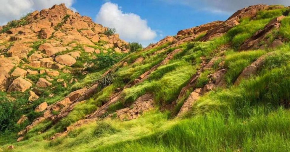
Counted among the lowest mountain ranges in the country, the Karoonjhar mountain range is only at a height of 305 meters above sea level. It has a total length of 19 kilometers. Experts in geology predict that this mountain range can be around 2,500 million years old.
It was a time when the entire surface of the earth was geologically active, and the continents, as we know them today, were being formed. This is why the region has interesting and uneven cliffy formations and thus belongs to one of the oldest rock systems. The place can be listed among the oldest tourist attractions in Sindh that have yet to be fully explored.
If you head east from the main range, you’ll see a region dotted with small hills and sparse vegetation, reflecting the typical topography of the area. Moreover, there are also a couple of temporary water streams known as Bhetiani and Gordhro. These streams flow during the rainy season, usually from July to September. It is also the best season for visiting the Karoonjhar Mountains in Tharparkar, Sindh.
So far, we have discussed the history and topographical features of this fantastic tourist attraction in Sindh. We’ll learn more about its location and the best routes to the Karoonjhar Mountains, Sindh.
LOCATION OF KAROONJHAR MOUNTAINS
The Karoonjhar mountain range is interestingly located near the Pakistan-India border. This is why the Pakistan Rangers guard the entire region. It is found in the area known as Nagarparkar, which is the southeastern edge of Tharparkar, Sindh.
The mountain range is around 132 kilometers southeast of the city of Mithi in Sindh through the route of Islamkot Road. It is also the best route to the Karoonjhar mountains in Sindh if you travel from major cities like Karachi or Hyderabad. You can also make a pit stop in Mithi, explore the city for a while, and then continue your journey.
The place is connected to some primary road links in the region. This makes it one of the most conveniently accessible tourist attractions in Sindh. If you are heading from Karachi, the fastest route to get you to your destination is National Highway 5. You’ll have to cover a distance of more than 450 kilometers, and your journey will take around 7 hours.
On the other hand, the distance between the Karoonjhar mountain range and Hyderabad is around 350 kilometers. The quickest route you can take in this regard is Hyderabad-Badin Road, which will be around a 5.5-hour-long journey.
Remember to stop and explore some of the most incredible historical attractions in Sindh, which you’ll come across along the road trip. So, let’s learn more about these heritage sites and what the concerned authorities are doing to preserve them.
TOURISM IN KAROONJHAR MOUNTAINS
The entire region of Nagarparkar and Tharparkar has an ancient history, so it holds extreme significance for tourism in Sindh. The Sindh Tourism Development Corporation (STDC) has listed it on its official website and has recently developed the Sardharo picnic point in Karoonjhar, Nagarparkar, to facilitate tourists.
A pedestrian bridge has also been recently constructed between two of the cliffs in the region for the ease of visitors. Like other sites popular for tourism in Sindh, the Sindh Tourism Development Authority (STDC) also plans to improve the infrastructure around the Karoonjhar mountain range in Nagarparkar.
Moreover, the authority is also working on rehabilitating and restoring historical attractions near the Karoonjhar Mountains. Some noteworthy mentions in this regard include the 16th-century Jain Gori Temple, Marvi’s Well (locally known as ‘Marvi jo koonh’), and Bhodesar Mosque.
These historical attractions near the Karoonjhar Mountains are worship places or sacred ritual sites from ancient times. So, if you are interested in exploring these historical sites in Sindh, let’s learn more about the best season for visiting the Karoonjhar Mountains in Tharparkar, Sindh.
WEATHER OF KAROONJHAR MOUNTAINS
To find out the best season to visit this mountain range in Sindh, we’ll have to examine the region’s weather closely. It is among those places to visit in Sindh that stays dry and dusty almost all year round. The main reason behind the dry and dusty weather in the Karoonjhar mountain range is that it is a part of the Thar desert, one of the largest deserts in Pakistan.
However, as discussed, the area receives little rain during the monsoon season, which usually lasts from July to September. In case you have started packing for your trip, here are a few things you should know before visiting this mountain range in Sindh
THINGS TO KEEP IN MIND DURING YOUR VISIT TO THE KAROONJHAR MOUNTAINS
- Pick a cloudy day for your visit since you can’t comfortably explore the mountain range in the scorching sun and desert heat. Temperatures can cross the 40-degree Celsius mark during the daytime.
- Avoid visiting the Sardharo picnic spot in Karoonjhar, Nagarparkar, if it is pouring. Landsliding is a regular occurrence in the area during the rainy season.
- The roads running through this mountainous and hilly terrain are thin and bumpy and must be appropriately carpeted. Keep all your focus on the streets while driving instead of gazing at mountainous views.
- Since there are no lighting arrangements in Karoonjhar, it gets pretty dark at night. So leave the site before the sun goes down.
- As mentioned earlier, the area is under the control of the Pakistan Rangers. This means no professional or drone cameras are allowed. You can only use the cameras on your smartphones to videotape your journey.
- Pack all the necessary hiking equipment with you for your safety. The mountainous and hilly surfaces in the region can get steep for hikers.
- Though you can easily spot some local cafeterias and dhabas along the way, it is better to pack your own food as well to be safe.


